Presentation by Sherry Olson
Presentation by Barbara Znamiroski
Links mentioned during the discussions
Presentation and theoretical and critical discussion of cartographic, digitized, iconographic and literary sources; identification and accessibility.
- Session moderator: Jean-François Palomino (BAnQ)
Presentation by Sherry Olson (McGill University)
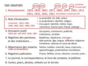
What sources have been mapped in the past ten years?
Using the same sources
Practitioners in the field of historical GIS often return to the same sources (census returns, municipal assessment rolls, directories, parish registers, etc.), which are nominal records that are already digitized and usually georeferenced. Such sources must be accessible, downloadable and available for consultation in digital form. Since they can take different forms and have different objectives, they must also be documented.
Sharing sources
If, as a group, researchers shared their sources and data, it would be easier to establish connections between various sources, including those which have not yet been processed, and thus generate a greater number of research questions.
Presentation by Barbara Znamirowski (Trent University)
Presentation on the integrated delivery of historical air photos in a web-based regional atlas (REHA ‚Äď Regionnal Environmental History Atlas of South Central Ontario).
The history atlas has several goals:
- To create a discovery tool for current and historical information including maps, imagery, spatial and statistical data, photographs, oral narratives, text and other resources.
- To encourage research and teaching that fosters new ways of understanding our region.
- To encourage interdisciplinary collaboration within Trent University and with regional partners and members of the public.
While working on this project, participants had to resolve a number of questions related to digitization, database development and the work process. To achieve the desired result, they had to use a number of tools and programming languages. A guide to digitization best practices (available upon request) was also created.
While working on this project, participants had to resolve a number of questions related to digitization, database development and the work process. To achieve the desired result, they had to use a number of tools and programming languages. A guide to digitization best practices (available upon request) was also created.
Without the cooperation of other institutions, which not only shared images and metadata but also contributed to work methods, the project would not have had the same scope. Therefore, with regard to the exchange of information and data, various institutions and different levels of government should be encouraged to work together in the future.
Links mentioned during the discussions
- Quebec land registry: https://www.registrefoncier.gouv.qc.ca/
- Ontario Land Registry:  http://www.gov.on.ca/en/information_bundle/land_registration/STEL01_130081.html
- BALSAC Project: http://balsac.uqac.ca/english
- Ian N. Gregory, “Visual GISting: Bringing Together Corpus Linguistics and Geographical Information Systems,”¬†Literary and Linguistic Computing (2011), 26 (3): 297-314: http://llc.oxfordjournals.org/content/26/3/297


